Places · Famagusta district
Kapparis, Cyprus: where it is, its four Blue Flag coves, the winter buses and the Famagusta crossing
Where Kapparis actually is, why it is neither a village nor quite Protaras, the four Blue Flag coves and the nicknames the maps use for them, which buses run along Kappari Avenue this winter and how close you are to the Deryneia crossing.
- Filed under
- Places
- Updated
- 15 November 2026
- By
- The editors
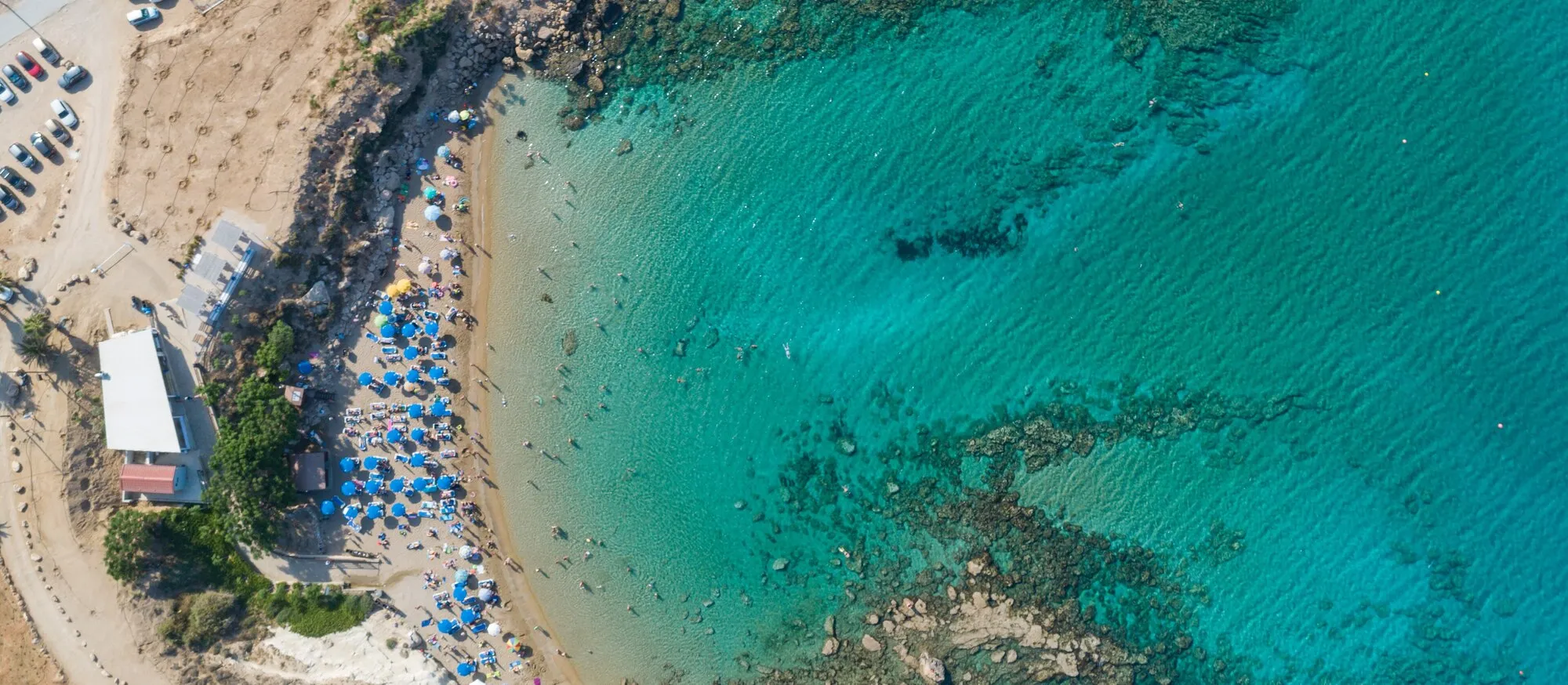
Kapparis is the northernmost part of the Paralimni and Protaras coast on the east side of Cyprus: a quiet residential and villa district strung along Kappari Avenue, about 4 km from Paralimni town, 7 km north of Fig Tree Bay and 11 km from Ayia Napa. It has four small coves on the 2026 Blue Flag list, a handful of buses a day rather than the every-ten-minutes service central Protaras gets, and the UN buffer zone and Deryneia crossing to Famagusta about 6 km away. It is not a village and has no centre as such, which is the first thing most pages about it get wrong.
Search for Kapparis and you get estate agents, booking sites and an Instagram account. None of them tells you which beach is which, what the bus numbers are or what happens there in January. This guide works from the national Blue Flag list, the Deputy Ministry of Tourism’s beach pages and the bus operator’s winter timetable, which came into force the day after this was written.
Where Kapparis is, and what it is
Wikipedia and several map sites call Kapparis a village. It is not one in any administrative sense: it has no community council and no census line of its own. It is a district of Paralimni, which since the local government reform of July 2024 forms part of the merged Paralimni-Deryneia municipality. The name on the road signs and the bus stops is Kappari, and the district is in effect the land either side of Kappari Avenue, the road that leaves Paralimni heading north-east and bends south along the coast to become Pernera Avenue and then Protaras Avenue.
That makes Kapparis the top of the resort strip. Going south you pass Pernera, then the centre of Protaras and Fig Tree Bay, then Konnos and Cape Greco, and only then Ayia Napa. Going north there is nothing but open coast and, shortly, the buffer zone.
| From Kappari Avenue | Distance | Drive |
|---|---|---|
| Agia Triada beach | 1.9 km | about 4 minutes |
| Paralimni town centre | 3.8 km | about 6 minutes |
| Pernera harbour | 3.8 km | about 5 minutes |
| Deryneia crossing point | 6.2 km | about 10 minutes |
| Fig Tree Bay | 7.2 km | about 10 minutes |
| Konnos Bay | 10.3 km | about 17 minutes |
| Ayia Napa centre | 10.8 km | about 16 minutes |
| Larnaca Airport | 65.5 km | about 58 minutes |
Distances and times are from the OSRM routing engine on OpenStreetMap data, measured from the middle of the avenue, without traffic. For the airport run by bus, shuttle and taxi, see our Larnaca Airport to Protaras guide; the same options apply, with a few minutes less on the road.
The four coves, and what the maps call them
The 2026 national Blue Flag list published by CYMEPA, the body that runs the scheme in Cyprus, has 14 beaches under Paralimni. The first four, listed north to south, are the Kapparis ones. The confusion comes from the fact that almost nobody uses the official names.
| Official name (CYMEPA 2026) | Also called | What the official page says |
|---|---|---|
| Armyropigado | Scouts’ Beach on OpenStreetMap | On the Blue Flag list; no Visit Cyprus page of its own |
| Kappari | Kapparis Beach; Fireman’s Beach on maps; “M.M.A.D” in Google’s panel | Fine golden sand at the end of a 1 km track; toilets, changing rooms, sunbeds, umbrellas, water sports, car park |
| Skoutarospilioi | Skoutari Beach; Malama Beach | Sand and rock; toilets, showers, changing rooms, sunbeds, water sports; no disabled access |
| Agia Triada | Trinity Beach | Fine golden sand beside a small fishing harbour and the Agia Triada chapel; toilets, changing rooms, sunbeds, water sports |
Kapparis beach is the one the area is named after and the one Google’s knowledge panel shows. Visit Cyprus calls it “the furthest coastal strip of the area” and describes a relatively secluded beach at the end of a 1 km track, which is accurate: it sits below the avenue, away from the buildings. The ministry’s accessibility listing records ramps and an accessible toilet but no disabled parking bay and only partial signage.
Skoutarospilioi is the cove most British visitors know as Malama Beach, after the holiday village beside it; “malama beach” is searched more often in the UK than “kapparis beach”. The official page is candid that it is a mix of sand and rock and has no disabled access.
Agia Triada, or Trinity Beach, is the southernmost and the easiest to reach, with the chapel and fishing shelter beside it. It is where Kapparis shades into Pernera, and our Pernera guide treats it as the top of that district’s run of bays.
All of these are small. If you want a long beach with a full line of water sports, Fig Tree Bay is ten minutes south, and our Protaras beaches guide compares the whole coast bay by bay. Lifeguards are on duty at the Blue Flag beaches from April to October, according to the ministry; outside those months you swim unsupervised.
Buses: what actually runs along Kappari Avenue
This is where Kapparis differs most from the rest of Protaras. The 101 and 102, the buses that run every ten to twenty minutes in summer between Paralimni, Protaras and Ayia Napa, go down Pernera Avenue and do not come through Kapparis at all. The operator’s stop lists show four routes using the Kappari Avenue stops: 711, 706, 301 and the once-a-day 510.
OSEA, the Famagusta district operator, published its winter timetable valid from 16 November 2026 to 31 March 2027. All of these run every day.
| Route | Where it goes | Departures from the starting point |
|---|---|---|
| 711 | Paralimni, Kapparis, Protaras, Konnos, Ayia Napa, Larnaca, Metropolis Mall (150 minutes end to end) | From Paralimni: 05:20, 07:15, 08:00, 09:45, 10:30, 13:00, 14:15, 15:30, 17:00, 18:45. From Metropolis Mall: 08:15, 10:15, 11:00, 13:45, 16:10, 17:15, 18:30, 20:00, 21:45 |
| 706 | Xylotymbou, Frenaros, Deryneia, Kapparis, Protaras, Konnos (75 minutes) | From Xylotymbou: 05:25, 06:10, 13:50, 18:15, 21:30. From Konnos: 07:30, 15:30, 16:00, 20:00, 23:00 |
| 301 | Paralimni circle: St George Square, Kappari, Protaras Avenue, Agia Varvara and back (40 minutes) | Hourly from 08:15 to 21:15, with no 13:15 |
| 510 | Famagusta General Hospital, Kapparis, Paralimni, Ayia Napa, Agia Thekla beach | One a day: 05:45 out, 15:25 back |
Those are departure times from the first stop, not from Kapparis; the Kappari Avenue stops come a few minutes after Paralimni on the 711 and the 301. The 711 timetable carries a note asking passengers bound only for Ayia Napa to use the 102 from Protaras instead because the 711 gets crowded, and it does not let you board or alight for local journeys inside Larnaca.
Fares on the timetable are 2 euros for a single between 04:00 and 21:00, 3 euros at night, 6 euros for a day ticket, 20 euros for five days, 25 euros for seven and 50 euros for thirty. The summer timetable is a separate document with different times, so check the OSEA routes page for your dates. How buses work across the island is in our Cyprus public transport guide.
In practice a week in Kapparis without a car is workable if you plan around the 711 and the 301, and awkward if you expect to step out and catch something. Most villa guests hire a car; our Cyprus car hire guide covers what that involves.
The Famagusta side: the buffer zone and the Deryneia crossing
Kapparis is the last built-up stretch of coast before the UN buffer zone, and from the higher ground you look north across the bay to the skyline of Famagusta and the empty hotel blocks of Varosha. That proximity shapes the place more than any of the listings mention.
The Deryneia crossing point, which opened on 12 November 2018 as one of the first new crossings in eight years, is about 6 km and ten minutes away by car. From there the walled city of Famagusta, the ruins of Salamis and the reopened part of Varosha are all a short drive, which makes Kapparis one of the most convenient bases in the Republic for a day on the other side. You need a passport or EU identity card, and motor insurance bought in the Republic does not cover you in the north. Our Green Line crossing guide explains the documents, the insurance question and what hire companies allow.
If you would rather look than cross, the cultural centre in Deryneia, a few minutes inland, has a viewing point over the buffer zone towards Famagusta.
Weather and the winter question
The nearest Meteorological Service station is at Paralimni, about 4 km inland at 70 m, and its long-term table is the one to use for Kapparis.
| Month | Mean daily max | Mean daily min |
|---|---|---|
| January | 16.0 C | 8.6 C |
| April | 22.2 C | 12.5 C |
| June | 30.8 C | 20.6 C |
| August | 33.3 C | 23.7 C |
| October | 27.7 C | 18.0 C |
| November | 21.7 C | 13.4 C |
Meteorological Service (Cyprus) figures for Paralimni as reproduced on Wikipedia’s Climate of Cyprus page. The official Visit Cyprus climate table puts the sea at 24 C in June, 27 to 28 C from July to September, 25 C in October and 22 C in November.
Kapparis is often described as open all year, and the claim holds better here than further down the strip. The district has permanent residents, and the buses above run daily through the winter. What does close is the beach side of things: lifeguards leave at the end of October and the Deputy Ministry of Tourism lists beach services as seasonal. Central Protaras shuts down far more thoroughly, so in winter Kapparis and Paralimni town are where the open kitchens tend to be. The avenue has tavernas, bars, bakeries and mini-markets; we have not listed individual venues because opening patterns change from season to season and we could not verify them from an official source.
UK search interest in Kapparis peaks in February and March, not in summer. That is the booking window, and it suggests people are choosing it deliberately from a listing rather than stumbling on it.
Kapparis, Pernera or central Protaras?
| Kapparis | Pernera | Central Protaras | |
|---|---|---|---|
| Character | Residential, villas and apartments | Quiet resort round a fishing harbour | Hotel strip and main bar street |
| Beaches | Four small Blue Flag coves | Five small Blue Flag bays | Fig Tree Bay and the Vrysi beaches |
| Buses | 711, 706, 301: a few an hour at best | 101/102 plus the 711 | 101/102 plus the 711 |
| Winter | Residents year-round, daily buses | Much quieter | Largely closed |
| Nearest to | Paralimni town, Deryneia crossing | The harbour and coastal path | Cape Greco, Ayia Napa |
Kapparis suits a villa or apartment holiday with a car, a longer winter stay, or anyone who wants the Famagusta side within easy reach. If you want to walk to a choice of beaches and restaurants and use the bus without thinking about it, Pernera or the centre is the better fit; our Protaras or Ayia Napa comparison helps with the wider decision.
The short answer
Kapparis is the quiet northern edge of the Protaras coast: a district of Paralimni rather than a village, with four small Blue Flag coves that go by more than one name each, daily buses on routes 711, 706 and 301 rather than the frequent 101, and Famagusta a few kilometres up the coast. Book it for space and calm, hire a car if you can, and go south for the big beaches.
Sources for changing details: the CYMEPA 2026 Blue Flag list; the Visit Cyprus pages for Kapparis, Skoutarospilioi and Agia Triada beaches and the Kapparis beach accessibility listing; the OSEA route stop lists and winter timetable, 16 November 2026 to 31 March 2027; and the UN peacekeeping force’s report on the 2018 crossing openings. Beach nicknames are as mapped on OpenStreetMap. Checked on 15 November 2026; bus times and beach facilities change with the season, so confirm before you travel.
Hero photograph: “Kapparis bay Cyprus” by dronepicr, Wikimedia Commons, licensed CC BY 2.0. Cropped for this page.

Quick answers
Frequently asked questions
Where is Kapparis in Cyprus?
Kapparis is the northernmost stretch of the Paralimni and Protaras coast, in the Famagusta district on the east side of Cyprus. It is a residential and holiday area along Kappari Avenue rather than a village with its own council, about 4 km by road from Paralimni town centre, 4 km from Pernera harbour, 7 km from Fig Tree Bay, 11 km from Ayia Napa and 65 km from Larnaca Airport. The UN buffer zone and the Deryneia crossing to Famagusta are about 6 km to the north-west.
What is Kapparis like?
Quiet and residential. Kapparis is a strip of villas, apartment blocks and a few small hotels along one avenue, with four small Blue Flag coves below it and a mix of tavernas, bars and shops used by residents as well as visitors. It has no nightlife district and no large hotel strip, which is why it suits villa holidays, longer winter stays and people who want Protaras and Ayia Napa within a short drive rather than on the doorstep.
Is Kapparis beach a Blue Flag beach?
Yes. The 2026 national Blue Flag list published by CYMEPA has four Paralimni beaches on the Kapparis side: Armyropigado, Kappari, Skoutarospilioi and Agia Triada. Maps and locals often use other names for them, including Fireman's Beach for Kapparis beach, Malama Beach for Skoutarospilioi and Trinity Beach for Agia Triada. The Deputy Ministry of Tourism says lifeguards are on duty from April to October.
Is there a bus from Kapparis to Protaras and Ayia Napa?
Yes. Route 711 runs along Kappari Avenue from Paralimni to Protaras, Konnos, Ayia Napa and on to Larnaca, with ten departures a day from Paralimni and nine back under the winter timetable valid from 16 November 2026 to 31 March 2027. Route 706 adds five journeys a day each way to Protaras and Konnos, and the 301 circle line links Kapparis with Paralimni town roughly hourly. A single ticket is 2 euros by day and 3 euros at night. The frequent 101 and 102 buses do not run through Kapparis.
How far is Kapparis from Famagusta?
Close. The Deryneia crossing point, which opened in November 2018, is about 6 km and ten minutes by car from Kappari Avenue, and the walled city of Famagusta is a short drive beyond it on the other side. You need a passport or EU identity card to cross, and hire-car insurance bought in the Republic does not cover the north, so check with your hire company first.