Places · Famagusta district
Liopetri, Cyprus: the red-soil village, the Potamos fishing inlet and what the rebuild means for visitors
What Liopetri is, why the village and its famous fishing inlet are 4 km apart, where the long-running Potamos rebuild stands in late 2026, what to see in the village itself and how the buses from Ayia Napa and Paralimni work.
- Filed under
- Places
- Updated
- 21 November 2026
- By
- The editors
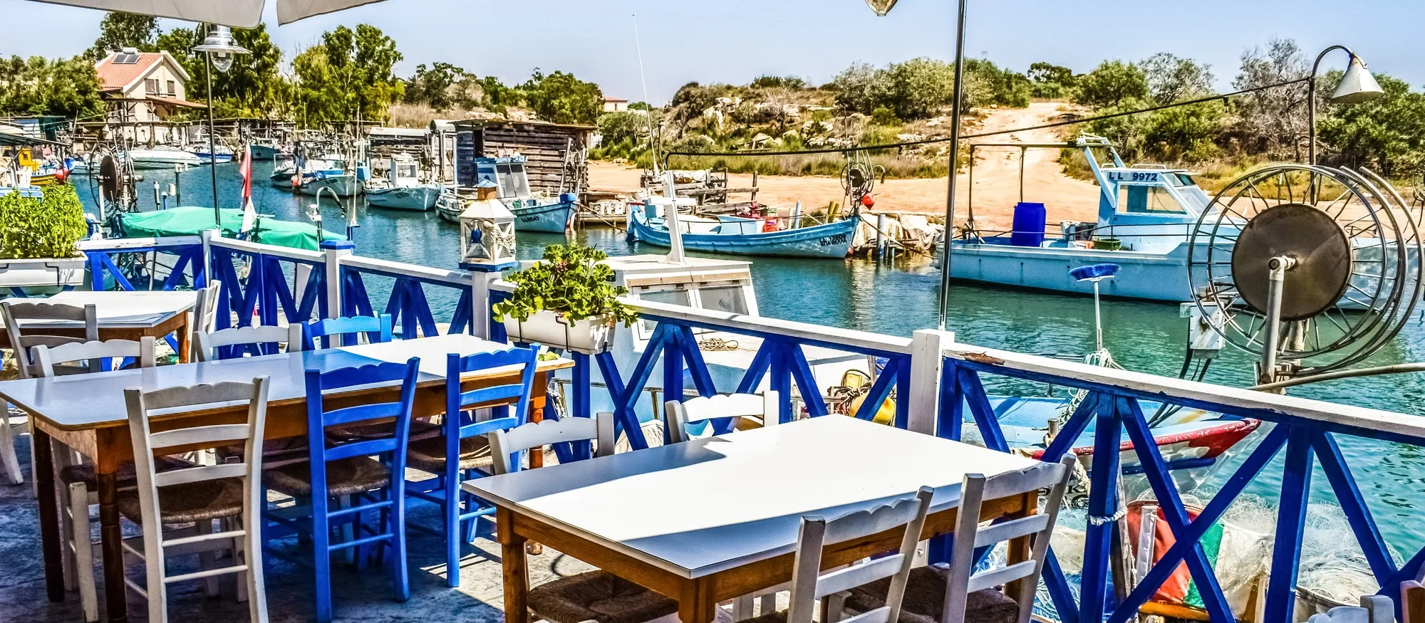
Liopetri is a farming village of about 4,900 people in the Famagusta district, 16 km by road from Ayia Napa. Most people who search for it are really looking for Potamos tou Liopetriou, the narrow sea inlet lined with fishing boats that is sold as the “Liopetri river”. That inlet is on the coast about 4 km south of the village, it has been a building site for most of the past six years, and by late 2026 the rebuild was still not reported complete. Go for a fish lunch by the water and an hour in the village, and go knowing what you will find.
Search for Liopetri and the first page is property portals, a Wikipedia stub and map sites. None of them says that the village and its best-known sight are two separate stops, or that the inlet in the photographs no longer looks like the photographs. This guide works from the Deputy Ministry of Tourism, the Famagusta regional tourism board, the bus operator’s winter timetable, census figures and the Cyprus Mail’s reporting on the project.
Where Liopetri is
Liopetri lies on the flat, red-earth plain west of Ayia Napa, between Frenaros to the north, Sotira to the east and Xylofagou, which is in the Larnaca district, to the west. It is one of the Kokkinochoria, the “red-soil villages”, named for the iron-rich earth that grows the Cyprus potato. The regional tourism board, Visit Famagusta, now describes it as a municipal quarter of Ayia Napa, which it has been since the local government reform of July 2024.
The census shows steady growth: 2,854 residents in 1982, 3,837 in 2001, 4,591 in 2011 and 4,908 in 2021. Wikipedia and Google’s information panel still quote the 2011 figure.
Driving distances below come from the open-source OSRM routing engine and are rounded.
| From Liopetri village square | Distance | Drive |
|---|---|---|
| Potamos tou Liopetriou (fishing inlet) | about 4 km | about 6 minutes |
| Ayia Thekla beach | about 7.5 km | about 9 minutes |
| Paralimni | about 11 km | about 15 minutes |
| Ayia Napa centre | about 16 km | about 17 minutes |
| Larnaca seafront | about 37 km | about 37 minutes |
| Larnaca Airport | about 49 km | about 40 minutes |
Two places under one name
The village is inland. Its centre is a square with coffee shops, the medieval church of the Virgin Mary and the newer parish church, surrounded by ordinary houses and a few older ones of mud brick and straw. There is no sea view.
The inlet is a different trip. Potamos tou Liopetriou is at the southern edge of the community’s land, where a finger of sea runs inland between low banks. Potamos means “river”, and visitor sites call it one, but it is salt water and nothing flows down it. The Deputy Ministry of Tourism lists it as the “Potamos Liopetriou Natural Fishing Shelter”, one of five fishing shelters in the Famagusta region. From Ayia Napa you reach it along the coast road past Ayia Thekla without going near the village at all: about 14 km and a quarter of an hour.
So if a listing says “Liopetri”, check which one it means. A villa “in Liopetri, near the river” is on the coast, beside the Ayia Thekla villa belt. A house “in Liopetri village” is 4 km inland among the potato fields.
Potamos tou Liopetriou: what it was and what it is now
For decades Potamos was the least-developed corner of this coast. Fishermen tied their boats to makeshift wooden jetties along both banks, turtles swam in the channel, and two tavernas served the catch at tables over the water. The hero photograph on this page, taken in 2017, shows that version.
That version has gone, and the replacement is not finished. The Cyprus Mail has followed the story, and the sequence it reports is this:
| Date | What happened |
|---|---|
| 2018 | Renovation of the shelter proposed |
| 2020 | Work begins on an €8 million project, 75% funded by the EU fisheries fund, due for completion in 2023 |
| November 2024 | The government terminates the contract with the job about half done |
| March 2025 | Work resumes under the interior ministry |
| 19 July 2025 | The new road network at the inlet opens to the public |
| 23 December 2025 | A €3.6 million contract is signed to finish the jetties over 12 months |
| May 2026 | Work still under way; the mayor says the 12 months will probably be extended |
The December 2025 contract covers the jetties only. According to the same report, the buildings, car parks and the bridge between the two banks are to follow under a further contract once the jetties are delivered. The finished scheme is meant to have paved roads, pavements and cycle lanes, boat facilities, soft lighting, a visitors’ car park, a fishing education centre and a multi-purpose hall.
The project has cost the place something already. During the years when the only way in was a rough detour across fields, visitor numbers fell away, and the Cyprus Mail reported in May 2026 that one of the two tavernas had closed permanently. The inlet is also inside a Natura 2000 protected area, designated for the greater sand plover; BirdLife Cyprus opposed the scheme from 2018 and says little of the original habitat is left. The mayor of Ayia Napa takes the opposite view and expects a landmark. Locals quoted by the paper were mostly in favour of the power and water connections, with reservations about the rest.
We found no report of completion when this page was checked on 21 November 2026. In practical terms:
- You can drive there. The access road has been open since July 2025.
- Expect some fencing, machinery and unfinished surfaces until the remaining contracts are done.
- Ring the taverna before you set out for lunch, especially in winter. With one of the two closed, there is no second option on the water.
- It is still a working harbour. Boats come and go, nets are mended on the bank, and the fishermen are not there for the photographs.
The small chapel of Agios Georgios stands near the inlet, with benches under trees in its yard. Visit Famagusta gives no date for it beyond “old”.
Is there a Liopetri beach?
A modest one. Visit Famagusta describes a small beach of sand and rock beside the inlet and a quiet stretch of coast away from the Ayia Napa crowds. It has none of the organised facilities of the resort beaches, and no Liopetri beach appears on the 2026 Blue Flag list. For sunbeds, lifeguards in season and a Blue Flag, Ayia Thekla beach is about 5.5 km east by road, and Makronissos a little further.
What to see in the village
The Akhyronas barn. On 2 September 1958, during the armed campaign against British rule, four EOKA fighters, Fotis Pittas, Andreas Karios, Elias Papakyriakou and Christos Samaras, were surrounded in a barn in Liopetri by soldiers of the Royal Ulster Rifles and killed after a long gun battle in which a British soldier also died. The barn is now a national memorial and small museum on the main road through the village, with bronze statues of the four men in the forecourt. Visit Famagusta notes that the signs and texts are in Greek and that it is aimed mainly at Greek Cypriot visitors. Neither tourism body publishes opening hours, so treat the interior as a bonus; the forecourt and statues can be seen from the street.
The church of the Virgin Mary (Panagia). A small domed stone church in the centre, which the Deputy Ministry of Tourism dates to the 16th century, with an arcaded porch. Its feast on 15 August closes the square for an evening of music and dancing.
Agios Andronikos. A 15th-century church with an octagonal dome and the remains of wall paintings in the apse.
Baskets and produce. Liopetri is one of the villages where basket making is still practised. The fields produce potatoes, carrots and watermelons, plus pomegranates and figs, and the village holds a summer Carrot Festival. Our Cyprus food guide explains where the red-soil potatoes end up on a menu.
The Rimbaud footnote. The Deputy Ministry of Tourism says the French poet Arthur Rimbaud worked at an old quarry at Potamos. Visit Famagusta places this “in the 1880s”; his biographers have him in Cyprus as a quarry foreman from December 1878 until fever sent him home in mid-1879. There is nothing to see, but it is a good story for the drive.
Getting there without a car
Buses in the Famagusta district are run by OSEA. Its winter timetable, valid from 16 November 2026 to 31 March 2027, lists two routes through Liopetri village.
| Route | Runs | Departures in the winter timetable |
|---|---|---|
| 501 | Loop: Deryneia, Frenaros, Liopetri, Agia Thekla Beach, Ayia Napa Marina, WaterWorld, Ayia Napa, Paralimni, Famagusta Hospital, Deryneia (90 minutes) | 16 a day from Deryneia, 05:55 to 00:00 |
| 502 | The same loop in the opposite direction | Listed in the same document, but under a summer date label; confirm before relying on it |
| 705 | Ayia Napa, Liopetri, Avgorou, Dasaki Achnas (60 minutes) | 8 a day from Ayia Napa (07:45, 09:00, 11:45, 15:30, 16:00, 17:40, 19:30, 23:00); 7 a day from Dasaki Achnas |
The times printed are departures from the first stop, so allow for the journey to wherever you board. Fares are €2 for a single between 04:00 and 21:00, €3 at night and €6 for a day ticket. Our public transport guide covers how tickets work across the island.
The catch is the inlet. The published stop lists name Liopetri, meaning the village, and the nearest stop to the water that we could find on OpenStreetMap is in the Agia Thekla tourist area, roughly 750 m east in a straight line. Without a car, the realistic options for Potamos are a taxi from Ayia Napa or a bicycle; Visit Cyprus publishes an Agia Napa to Pyrgos Xylofagou cycling route that heads west through this area.
From Larnaca Airport there is no direct bus to Liopetri. Take the airport service to Ayia Napa, described in our Larnaca Airport to Ayia Napa guide, and change, or hire a car.
When to go and how to fit it in
Liopetri has no weather station of its own. Paralimni, about 11 km away on the same plain, is the nearest, and its Meteorological Service averages run from a 16.0°C daytime high in January to 33.3°C in August, with no rain to speak of in high summer. The month-by-month table is in our Paralimni guide.
Winter and spring suit the place best. The fields are green, the countryside round the inlet fills with wildflowers in spring, and a fish lunch by the water is more comfortable at 20°C than at 35°C. In July and August come in the evening.
A sensible half day from Ayia Napa or Protaras: the barn memorial and the two churches in the village first, then down to Potamos for lunch, then back along the coast with a stop at the Ayia Thekla chapel. If you are collecting quiet inland places, Paralimni and the Ayia Napa monastery fit the same loop, and our best villages in Cyprus list has the mountain alternatives.
The short answer
Liopetri is a red-soil farming village of about 4,900 people, 16 km from Ayia Napa, and its famous “river” is a sea inlet 4 km to the south. The inlet has been under reconstruction since 2020 and was not reported finished by late November 2026, so expect a working harbour with building work round it, phone the taverna first, and add the 1958 barn memorial and the two old churches to make a half day of it.
Sources for changing details: the Visit Cyprus Liopetri village page and fishing shelters list; Visit Famagusta’s Liopetri and Liopetri beaches pages; the Cyprus Mail reports of 19 July 2025, 23 December 2025 and 18 May 2026; the OSEA winter timetable; census figures via citypopulation.de; and the CYMEPA 2026 Blue Flag list. All checked on 21 November 2026. Project dates, taverna opening and bus times change; confirm them before you travel.
Hero photograph: “Cyprus Potamos Liopetri Fish Tavern Traditional” by dimitrisvetsikas1969, taken in August 2017, via Wikimedia Commons, released under CC0. Cropped for this page. It shows the inlet before the rebuild.

Quick answers
Frequently asked questions
Where is Liopetri in Cyprus?
Liopetri is a farming village in the Famagusta district in the south-east of Cyprus, about 16 km by road north-west of Ayia Napa and 49 km from Larnaca Airport. It is one of the Kokkinochoria, the red-soil villages. Since the 2024 local government reform it has been a quarter of Ayia Napa Municipality. Its fishing inlet, Potamos tou Liopetriou, is on the coast about 4 km south of the village square.
Is Liopetri worth visiting?
Yes, for half a day rather than a holiday base. The draw is Potamos tou Liopetriou, a narrow sea inlet used as a natural fishing shelter, with a fish taverna on the water. The village adds the Akhyronas barn memorial from 1958 and two medieval churches. Expect a working farming village, not a resort, and expect building work at the inlet until the rebuild is finished.
Is the Liopetri river a real river?
No. Potamos means river in Greek, but Potamos tou Liopetriou is a long, narrow inlet of the sea, sometimes described as a small fjord. Fishing boats moor along both banks because the water is sheltered. It is salt water and it does not flow through the village, which sits about 4 km inland.
Is the Potamos Liopetriou project finished?
Not as far as published reports show. Work on the 8 million euro upgrade began in 2020, the first contract was terminated in November 2024, the new road opened in July 2025 and a 3.6 million euro contract for the jetties was signed on 23 December 2025 for a 12-month period. In May 2026 the Cyprus Mail found work still under way and the mayor expected an extension. No completion report had appeared when this guide was checked on 21 November 2026.
Is there a bus to Liopetri?
Yes. OSEA route 501 runs a loop from Deryneia through Frenaros and Liopetri to Agia Thekla Beach, Ayia Napa and Paralimni, with route 502 running the same loop the other way, and route 705 links Ayia Napa, Liopetri, Avgorou and Dasaki Achnas. A single ticket is 2 euros by day and 3 euros at night. The published stop lists name Liopetri village, not the fishing inlet.