Troodos & Paphos · Seven falls, four kinds of access, one honest ranking
Waterfalls in Cyprus: the seven worth knowing, and which one suits your day
A practical guide to the waterfalls in Cyprus: heights from the regional sources, which you can drive to, which need a trail, which charges admission, and how to fit one into a real itinerary.
- Filed under
- Places
- Updated
- 13 September 2026
- By
- The editors
Cyprus has seven waterfalls worth naming, the tallest is roughly the height of a five-storey building, and the single most common mistake is choosing the wrong one for the day you have. Two of them sit at the end of proper mountain trails. Three you can effectively park beside. One charges €15 a head and calls itself a theme park. One involves squeezing through a gap in a rock face.
That range matters more than any ranking. A family with a hire car and two hours has a completely different best answer from a walker who wants the forest for a morning. This page sorts the falls by what the visit actually demands, using the heights and locations published by the Troodos Geopark, a UNESCO Global Geopark, and the regional My Troodos visitor site.
One expectation to set first. These are not headline natural wonders. They are small, shaded, pretty spots on mountain rivers, and the walk in is usually the better half of the experience. Go for the pine forest and the cold air and you will enjoy them; go expecting a spectacle and you will not.
Every Cyprus waterfall at a glance
| Waterfall | Where | Height | Getting there | Free? |
|---|---|---|---|---|
| Caledonia (Kalidonia) | Kryos river, 2 km north of Pano Platres | 13 m | 3 km nature trail, difficulty 3 | Yes |
| Millomeris | Kryos river, 1 km south of Pano Platres | 20 m | 1 km nature trail, or by car on an unmade approach | Yes |
| Chantara | Diarizos river, 1.5 km north of Foini | 8 m | By car | Yes |
| Mesa Potamos | Near Timios Prodromos monastery, above Saittas | 7 m | By car, then about 200 m downhill | Yes |
| Mavritsios | Serrachis river, 1 km southeast of Gourri | 8 m | Nature trail or by car | Yes |
| Adonis Baths | Near Kili, Paphos district | Not published | By car, following road signs | No, €15 adult |
| Kremiotis | Kritou Terra, Paphos district | Not published | Park above, walk down, short scramble | Yes |
Heights and locations for the first five come from the Troodos Geopark listing. Adonis Baths and Kremiotis are outside the Geopark’s published set, which is why no official height is quoted for them here.
Which is the tallest? The answer is genuinely contested
It is worth dealing with this properly, because it is the second thing everyone asks and almost every page gets it wrong by simply picking a side.
Caledonia is the famous one. It has 2,800 Google reviews at 4.6 stars, it appears first on the Tripadvisor list, and a large share of the “tallest waterfall in Cyprus” claims online attach to it. Millomeris is the taller one, on the sources that ought to know. The Troodos Geopark puts Millomeris at 20 metres against Caledonia’s 13, and My Troodos calls it outright “the highest waterfall of the Troodos mountain range”.
The complication is that My Troodos is not internally consistent: its waterfalls page says 20 metres and its nature-trails page says 15 metres and “one of the highest natural waterfalls on the island”. Our Millomeris guide goes through that discrepancy in more detail.
The practical reading: Millomeris is probably the tallest, Caledonia is the better walk, and a seven-metre difference in a forest gorge is not something you will perceive anyway. Do not let the height claim pick your trip.
The two that are a proper walk
Caledonia Falls, via the Kalidonia trail
This is the one to choose if you want a morning in the forest rather than a photo stop. The Cyprus Department of Forests trail is 3 km, about 1.5 hours, graded difficulty 3 (the top of the local three-point scale), with roughly 150 m of elevation change. It follows the Kryos Potamos, which My Troodos says holds water year-round, through pine and golden oak at around 1,330 m altitude.
You can walk it in either direction. The upper trailhead is on the Troodos Square to Platres road, a few hundred metres off it and about 3 km from the square; the lower end is at Psilo Dendro in Pano Platres. Walking down from the top and back up is the common approach, and it means the climb comes when you are warm rather than at the start.
Difficulty 3 is not a formality. The path crosses and re-crosses the river on stepping stones and small bridges, and the rock beside the fall stays wet. This wants trainers or boots with grip, not sandals.
Millomeris
Shorter and steeper. The signed nature trail from the Faneromeni Church area in Pano Platres is about 1 km, and the local classification is difficult. There is also a road approach, described by regional sources as unmade, which makes it a condition-and-rental-agreement judgement rather than a shortcut. Our full Millomeris walkthrough covers both routes and which to pick.
Because both falls sit on the same river either side of Pano Platres, you can do the pair in one day with lunch in the village between them. That is the best single waterfall day on the island and it costs nothing.
The three you can drive to
Chantara, 8 m, sits on the Diarizos river 1.5 km north of Foini and is reachable by car. My Troodos places it 3.5 km from Trooditissa monastery and 5.5 km from Pano Platres, among plane trees and alder at about 1,035 m, with an eight-metre fall into a small pool. It pairs naturally with Foini’s pottery workshops.
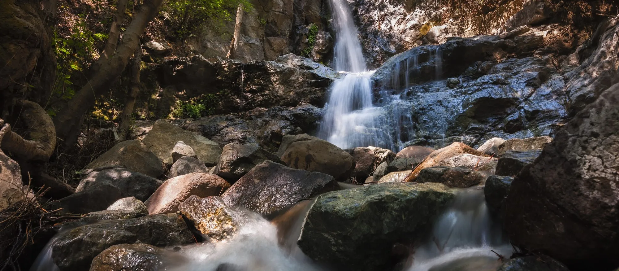
Mesa Potamos, 7 m, is north-west of Saittas near the Timios Prodromos monastery at about 1,000 m. The approach is straightforward: drive to the Mesa Potamos picnic site, then it is roughly 200 m downhill to the fall. That combination of a shaded picnic site with barbecue facilities and a short walk to water makes it the easiest of the mountain falls to do with young children or anyone who does not want a graded trail. It is the waterfall in the photograph at the top of this page.
Mavritsios, 8 m, is the outlier: on the Serrachis river 1 km south-east of Gourri, over on the Nicosia side of the range. It is reachable by trail or by car and it is a long way from the Platres cluster, so it only makes sense if you are already exploring the Pitsilia villages.
The two in the Paphos hills
Adonis Baths, the paid one
The only waterfall in Cyprus with a ticket desk. The operator lists €15 adults and €10 children, no time limit, bought on arrival, and the site includes statues, a museum, a watermill and a café alongside two falls you can swim in. Reviews are polarised, 3.9 from more than 6,000 of them, and the split is predictable: people who arrived on a tour rate it well, people who drove themselves rate it middling, people who expected a free wild swimming hole rate it badly.
One warning genuinely matters and almost nobody repeats it: the operator says Google Maps does not show the correct way in and asks visitors not to use GPS, directing drivers to follow road signs from Tala village or Coral Bay instead. Routing apps have repeatedly sent people onto an unsurfaced track. Our Adonis Baths guide has the current prices, the seasonal hours, the three approach roads and the phone number to confirm a late arrival.
Kremiotis, the awkward one
Near Kritou Terra, roughly 25 km north-east of Paphos at about 570 m altitude, in the hills behind Polis. It is free, and signposted from the village. You can drive part of the way down but the descent is steep enough that parking higher and walking is the sensible call, and the last stretch involves clambering over slippery rock and passing through a short narrow gap in the rock face, about three metres of it, to reach the fall.
That final squeeze is the whole story. It makes Kremiotis a small adventure for confident adults and a bad idea for anyone uneasy in tight or uneven spaces. If you are staying around Latchi or Polis it is a genuinely different half-day; from a Paphos or Limassol hotel it is a long way to go for it.
Choosing by the day you actually have
| If you have… | Go to | Why |
|---|---|---|
| A morning and want to walk | Caledonia, from the Troodos end | The best trail of the set, 3 km, free, river the whole way |
| A hire car and small children | Mesa Potamos | Picnic site at the top, about 200 m down to the water |
| A full day in the mountains | Millomeris and Caledonia | Same river, either side of Pano Platres, lunch between |
| A Paphos base and a budget for it | Adonis Baths | Swimmable pools, facilities, and a road you must follow by sign not GPS |
| A Polis or Latchi base and some nerve | Kremiotis | Free, quiet, and a squeeze through rock at the end |
| Only a couple of hours from Limassol | Chantara or Mesa Potamos | Both are car-access, both under an hour and a half up the hill |
Before you go: four things that spoil the trip
Check the road you are being sent down. The recurring failure across all of these is a routing app offering an unsurfaced short cut. Cyprus rental agreements commonly exclude unsurfaced and forest roads, and a car that can physically manage a track may still be outside its permitted-roads clause. Our car hire guide covers how to check that at collection, and driving in Cyprus covers the wider habit of trusting every line on a map.
Wear something with grip. Two of these are graded-difficult trails and the rest end on wet rock. This is the single most common cause of a bad afternoon.
Do not count on a bus. None of the seven has useful public transport to the trailhead. Our public transport guide explains what the network does and does not reach; for the mountains specifically, the Paphos to Troodos page sets out the realistic options.
Time it for water. Flow is a spring and early-summer story on the smaller falls. Caledonia and Millomeris, on the permanently flowing Kryos Potamos, are the two that hold up in August.
Fitting a waterfall into a wider trip
Waterfalls are a two-hour attraction, not a destination, and they work best bolted onto something else. The obvious pairings:
- With a mountain day. Our Troodos guide sets out the villages, the monasteries and the driving distances; Mount Olympus is half an hour from the Caledonia trailhead.
- With a walk. The Kalidonia trail is one of several in the Troodos National Forest Park, and our hiking in Cyprus guide puts it alongside the Artemis, Persephone and Atalanti routes.
- With a village lunch. Omodos and Kakopetria are both within range of the Platres falls.
- With a wet day out. If what you actually want is water you can play in, the water parks guide is the more honest answer than any of these.
The short answer
If you only do one, make it Caledonia and walk the trail properly from the Troodos end. If you have children or limited time, make it Mesa Potamos. If you want to swim and do not mind paying, make it Adonis Baths, and follow the road signs rather than your phone. Everything else on this page is for a second visit.
Sources: the Troodos Geopark waterfall listing for heights and river locations; the regional My Troodos waterfalls and nature trails pages for altitudes, distances and trail grades; and the Adonis Baths operator site for prices, facilities and its access warning. Published heights are inconsistent between sources and are reported as such above. Trail conditions, road surfaces and prices change, so confirm locally before travelling.
Hero photograph: “Mesa Potamos Waterfall HDR” by Anton Zelenov, licensed CC BY-SA 4.0. Cropped and resized for this page.

Quick answers
Frequently asked questions
Are there any waterfalls in Cyprus?
Yes, though they are modest by international standards. The Troodos Geopark lists five in the mountains: Caledonia at 13 metres, Millomeris at 20 metres, Chantara at 8 metres, Mesa Potamos at 7 metres and Mavritsios at 8 metres. There are also two more in the Paphos district at Adonis Baths and Kremiotis. Expect a forest stream over rock rather than a Niagara; the appeal is the walk in and the shade, not the scale.
What is the biggest waterfall in Cyprus?
The published sources disagree, which is why you will see the claim made for two different falls. The Troodos Geopark gives Millomeris as 20 metres against Caledonia's 13, and the regional My Troodos site calls Millomeris 'the highest waterfall of the Troodos mountain range'. But the Troodos nature-trail listing describes Millomeris as 15 metres, and plenty of tourist pages hand the title to Caledonia because it is the better known of the two. On the most consistent reading Millomeris is the taller and Caledonia the more visited.
Is there a waterfall in Paphos, Cyprus?
Two. Adonis Baths near Kili is a privately run attraction with an entrance fee, statues, a museum and pools you can swim in. Kremiotis, near Kritou Terra in the hills behind Polis, is free but harder: you park above, walk down a steep path and squeeze through a short narrow gap in the rock to reach the fall. Neither is in Paphos town itself; both need a car.
How much does it cost to visit the waterfalls in Cyprus?
All the Troodos waterfalls are free, and so is Kremiotis. The only one that charges is Adonis Baths, where the operator's own site lists €15 for adults and €10 for children with no time limit. Some third-party pages still quote an out-of-date €10 adult price. Parking at the Troodos trailheads is free but limited at weekends.
Can you swim in the waterfalls in Cyprus?
Adonis Baths is the one set up for it, with plunge pools and visitors who go in as a matter of course. The Troodos falls have small pools below them and people do dip, but none is a supervised swimming site: there are no lifeguards, no depth markings and the rock around them is wet and slippery. Treat a swim as your own risk assessment rather than an advertised facility, and keep children away from the lip of any fall.
When is the best time to see waterfalls in Cyprus?
Late winter through spring, when the mountain rain and meltwater are still moving. The Kryos Potamos, which feeds both Caledonia and Millomeris, is described by the regional visitor site as holding water through the summer, so those two are the safest bets in July and August. The smaller falls at Chantara and Mesa Potamos depend on recent rain and can be disappointing at the end of a dry summer.